FREE! Click here to Join FunTrivia. Thousands of games, quizzes, and lots more!
Quiz about Alliterative Place Names

Alliterative Place Names Trivia Quiz


All of these locations have two-word names that begin with the same letter. Can you locate them on this world map?

A label quiz by looney_tunes. Estimated time: 3 mins.
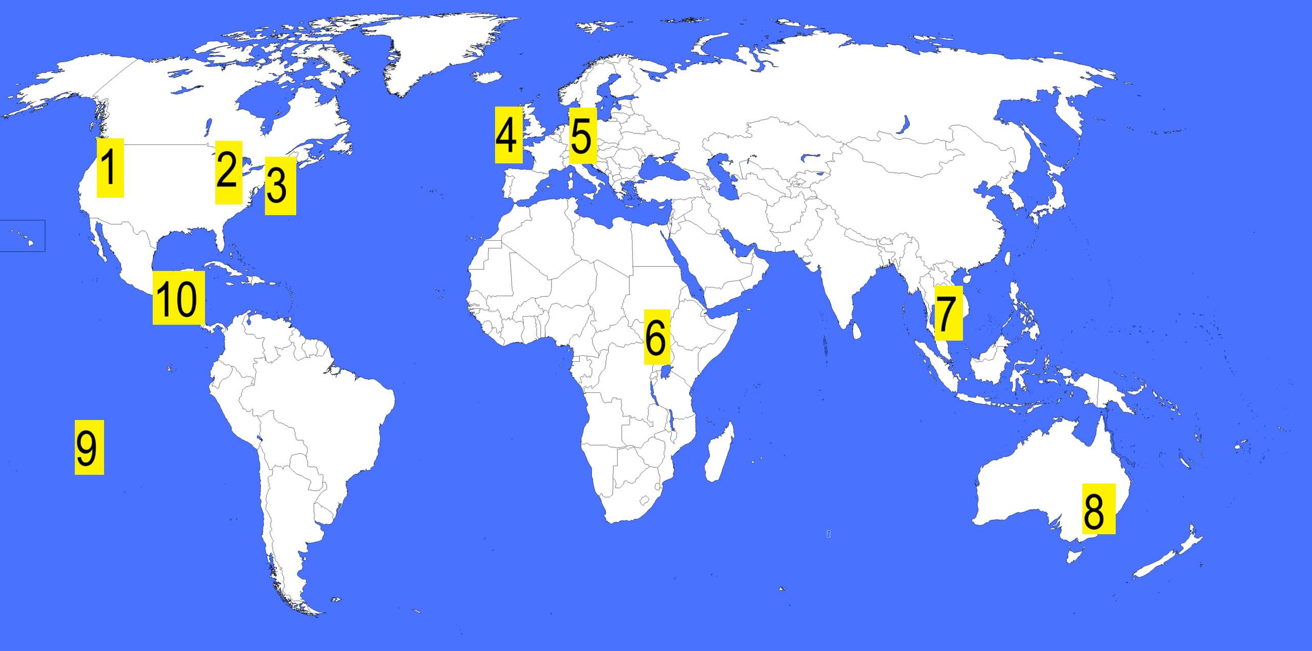
  1. Home
  2. »
  3. Quizzes
  4. »
  5. Geography Trivia
  6. »
  7. Names, Maps and Borders
  8. »
  9. Place Names

Author
looney_tunes
Time
3 mins
Type
Label Quiz
Quiz #
419,656
Updated
Apr 30 25
# Qns
10
Difficulty
Very Easy
Avg Score
10 / 10
Plays
414
Last 3 plays: Guest 174 (8/10), Kabdanis (8/10), Guest 121 (10/10).
Click on image to zoom
County Cork South Sudan San Salvador Phnom Penh Checkpoint Charlie Bora Bora Ann Arbor Cape Cod Wagga Wagga Walla Walla
* Drag / drop or click on the choices above to move them to the answer list.
View Image Attributions for This Quiz
1.   
2.   
3.   
4.   
5.   
6.   
7.   
8.   
9.   
10.   

Most Recent Scores
Today : Guest 174: 8/10
Today : Kabdanis: 8/10
Today : Guest 121: 10/10
Today : Guest 185: 7/10
Today : Guest 51: 10/10
Today : ncrmd: 10/10
Today : Guest 16: 2/10
Today : Stonecreek: 10/10
Today : Guest 165: 8/10

Quiz Answer Key and Fun Facts
1. Walla Walla

While there is also a town in eastern Australia called Walla Walla, that spot on the map has been allocated to Wagga Wagga, which can only be found in New South Wales. This label identifies the city of that name in the southeastern part of Washington State, or possibly the river of the same name at the mouth of which the Lewis and Clarke expedition encountered the Walla Walla people. The duplication indicates a diminutive form, and can be translated as 'many waters' or 'running waters', because the tribal region was centered on the region where the Snake River and the Columbia River joined. That was the location of Fort Walla Walla (unfortunately, established to control the regular fighting between the original inhabitants and the incoming settlers), around which the town was established in 1859. A gold rush shortly afterwards, accompanied by a burgeoning agricultural industry, turned Walla Walla into the largest city in the Washington Territory in 1878, when it was the site of the Washington State Constitutional Convention. When the transcontinental rail lines bypassed the area, growth slowed down.

The Walla Walla sweet onion, developed by Italian immigrants to have about half the sulfur content of an ordinary yellow onion, is celebrated every July in the Walla Walla Sweet Onion Festival; in 2007 it was declared the official state vegetable of Washington.

Walla Walla is also home to Adam West, best known either for portraying Batman on the television series of that name in the 1960s or for providing the voice of Mayor Adam West on the animated show 'Family Guy' between 1999 and 2019. The third Saturday in September was first celebrated as Adam West Day in 2017.
2. Ann Arbor

Located near the southeast corner of the lower part of Michigan, Ann Arbor was founded in 1824 by two men whose wives were both named Ann, so the settlement was named in their honour. Apparently the arbor was a reference to the many oak trees growing in the land they purchased. (And here was I, as a child, thinking it was somehow a corruption of harbor, and the city should be on the shore of one of the Great Lakes, rather than on the banks of Huron River.)

The land was purchased from the US government, which had gained possession from the indigenous residents of the area in the 1807 Treaty of Detroit. Prior to that, a number of Native American groups had inhabited the area, with the Potawatomi establishing two villages near what is now Ann Arbor in the 18th century. Other groups, including the Odawa and Ojibwe people, regularly passed through the area, with established trails coming together to form meeting places in the region.

The University of Michigan was founded in Ann Arbor in 1837, making it the oldest university in the state, and has remained a focus of the city's economic activity. This includes not only the education of students, but also its associated medical centre and technological research centres.
3. Cape Cod

When Bartholomew Gosnold designated this hook-shaped cape extending from the southeast corner of Massachusetts in 1602, it was actually a cape (although officially the name then only applied to the tip, later to be known as Provincetown). In 1914, construction of the Cape Cod Canal across the base of the peninsula has made it technically an island, but the name (one of the oldest English-language place names in the US) remains unchanged.

Cape Cod was definitely noted by a number of European explorers, possibly including Norse voyagers around 1000 CE. Giovanni da Verrazzano, an Italian explorer sailing for France, approached the southern side in 1524, and named the island now known as Martha's Vineyard after the French king's wife - Claudia. Portuguese explorer Estêvão Gomes, sailing for Spain, gave the cape the Portuguese name Cabo do la Arenas. Samuel de Champlain recorded a visit in 1606 and Henry Hudson in 1609. In 1620 the Pilgrims made their first landing at Provincetown on 11 November, staying there for a few weeks to repair their ships before proceeding to the 'official' landing place, Plymouth Rock, on 20 December.

The Wampanoag people who had established settlements on Cape Cod found themselves displaced, some captured and traded as slaves, many more dying of disease from visiting sailors and colonists, and the survivors displaced by settlers, either forcibly or peacefully. Subsequent deforestation to provide wood for fuel and grazing land for sheep and cattle led to increasing sand dunes invading the area. By the time the Industrial Revolution reached New England, the Cape was unable to sustain industry, and became increasingly dependent on whaling and fishing.

After the US Civil War, graziers headed west to the Great Plains, and Cape Cod's vegetation had a chance to recover. During the 20th century the Cape became an increasingly popular holiday venue, with tourists enjoying the beaches and (in season) whale watching. Summertime visitors come from around the world to engage in fishing, both along the coast and in the deeper ocean waters.
4. County Cork

The largest county in Ireland is (not that surprisingly) named after its largest city and county seat, Cork. In its southwest corner you will find one end of the famed Wild Atlantic Way, a tourist route that follows the western coastline of Ireland from Kinshale north to Inishowen Peninsula in Count. Cork is also the site of Blarney Castle, where you can find the famous Blarney Stone, kissing which is reputed to give one the 'gift of the gab', great facility in speech.

Many ships, including the Titanic, headed west from the port of Cobh (known until 1920 as Queenstown). Off the coast of County Cork in the Atlantic Ocean is Fastnet Rock, Ireland's southernmost point, sometimes called 'Ireland's Teadrdop' because it was the last bit of Irish land that was seen by Irish emigrants heading to North America during the Great Potato Famine in the 19th century.

Yachting fans will recognise Fastnet Island as a marker for a number of yachting races, especially the Fastnet Race. This biennial race sees competitors sail from Cowes (on the Isle of Wight, in the English Channel) around Fastnet Rock and back to the finish (Plymouth on England's south coast between 1925 and 2019, changed in 2021 to Cherbourg on the northern coast of France to accommodate a growing fleet).
5. Checkpoint Charlie

This is the most specific site in our quiz, selected because it was the inspiration. When the Berlin Wall was erected in 1961, it included a number of places, called checkpoints, where approved people could cross between West Berlin and the rest of East Germany. They were given letter names (A, B, C) which were translated into the military alphabet, so Checkpoint C became widely known as Checkpoint Charlie. Located at the intersection of Friedrichstraße and Zimmerstraße, this was a crossing point for both vehicles and pedestrians that could be used only by Allied personnel and non-German civilians. Called by the Soviets 'Friedrichstraße Crossing Point' and the East Germans 'Grenzübergangsstelle (which means border crossing point) Friedrich-/Zimmerstraße', this was one of the most high-profile locations on the Berlin Wall.

When the Wall was first erected in August, this was not a planned access point, and it was the source of considerable tension, with US and Soviet tanks lining up on opposite sides between 27 and 28 October, before both sides agreed to deescalate things. It was also at this site that President Kennedy gave his famous 'Ich bin ein Berliner' speech in June 1963.

Checkpoint Charlie was in operation for 28 years, between 1961 and 1989, when the Berlin Wall was removed as part of the reunification of Germany. While the East German side of the crossing was strongly reinforced (the original barbed wire being augmented by the actual wall, with a watch tower and extensive zig-zag barriers to make unauthorised crossing from that side a formidable task), the Allied side only erected a wooden shed, replaced in the 1980s with a metal shed, to act as a guardhouse for personnel checking the papers of those who wished to pass through. This lack of concern about guarding the border was attributed to the fact that it was not recognised as an international border, just one between two sectors of the city.

In 1998, the fiftieth anniversary of the Berlin airlift, the Allied Museum, intended to show the history of post-WWII Germany, especially in Berlin, was opened near the former US Army headquarters in Dahlem, part of the American sector of the divided city. The second American guardhouse from Checkpoint Charlie was relocated there.
6. South Sudan

South Sudan was established in the early part of the 21st century as a breakaway section of Sudan, its northern neighbour. The break followed years of conflict between the government and the Sudan People's Liberation Army/Movement (SPLA/M) between 1983 and 2005. Because it emerged from war, South Sudan started off with a weak economy and poor infrastructure, but a transition from rural subsistence farming to a more urban and technologically developed lifestyle has been in progress since independence.

In 2011 the government of South Sudan was established as a federal presidential republic (a form of government shared by countries such as the USA), with a provisional government in place. Ongoing conflict within the new nation (the civil war was officially settled in 2020, but there continues to be unrest at the local level) meant that there have not, as of 2025, been any actual elections for a government, with the elections agreed to in the treaty postponed multiple times at the agreement of both sides.

The conflict in South Sudan can to some extent be attributed to the continuing impact of colonialism, with the British placing more emphasis to developing the northern part of Sudan, a region which is characterised as Arabic. The southern part, inhabited by multiple African tribes, was largely ignored by the government, but was the focus of much missionary work, leading to a largely Christian population coming from multiple ethnic backgrounds. There are over 60 languages spoken in South Sudan, with English the official language (although few speak it as their first language) and Arabic the lingua franca (due to long association with the northern part of Sudan). There is a push to add Swahili, encouraging closeness with the East African League.
7. Phnom Penh

Although the first word in the name of the capital city of Cambodia looks as if it might start with an F sound, it is actually a two-syllable word, pronounced Puh-nom. the H at the end of the second part of the city's name is not pronounced. The name comes from the story of the city's founder (Lady Penh, in 1372) and the Buddhist temple she built for her village, Wat Phnom. According to the story, she found a Koki tree floating in one of the nearby rivers (the city is at the point where the Tonlé Sap joins the Mekong River and the Bassac River begins as a distributary branch), inside of which were five statues: four of Buddha and one of Vishnu. She then arranged for the villagers to construct an artificial hill to be the site for a temple, where the statues were placed.

Phnom Penh has had a chequered history, becoming the national capital between 1434 and 1497, then was designated the regional capital when the French Protectorate was established in 1863. It became the national capital when independence was achieved in 1953, but in 1975 the Khmer Rouge, under the leadership of Pol Pot, forcibly removed the entire population, most of whom were actually refugees from the fighting of the Vietnam War, which spilled over into Cambodian territory. The Khmer Rouge intended to establish an agrarian revolution, removing the (in their eyes) weak, educated elitist sponges on the workers from their parasitic position of power.

The period from 1975 through 1979, when the Khmer Rouge were overthrown by the People's Army of Vietnam, is often referred to as The Killing Fields. This refers not only to those who died under forced labour, but also the the specific site, Choeung Ek, where prisoners who had been tortured in Tol Seung (a school converted into a prison, now a museum to the genocide of the time) were taken to be killed and buried in shallow pits. While the liberation of the city by the Vietnamese, a traditional enemy of the Cambodian people) was seen by some as a mixed blessing, the city was able to be restored to a thriving center, and the seat of government following the restoration of Cambodia's monarchy in 1993.
8. Wagga Wagga

The Wiradjuri people had settled in the valley near the Murrumbidgee River well before colonists arrived in 1829 to stake claims (at first illegally, then licensed from 1836) near a suitable crossing place. The village was officially listed in 1849, and grew rapidly. By the end of the century, its position almost exactly halfway between Sydney and Melbourne made it a candidate to be the capital of the nation that was to be established in 1901, but it was eventually decided to have a purpose-built city, and Canberra was constructed. Wagga Wagga continued to be a major rural centre, reaching city status in 1946. It is a trucking transport centre, due to its location on the Sturt Highway (which runs from Adelaide to the eastern states) about 50 km from its junction with the Hume Highway, the main Melbourne-Sydney road.

Like many Australian place names that come from indigenous languages, the meaning is unclear, since communication between the local people and the settlers was poor (and there were many dialects, not a single language used by all indigenous people). The duplication is thought to have the usual intent of intensifying the meaning of the word, so the original suggestion that 'wagga' meant crow led to the official understanding of the city's name as 'place of many crows'. However, it has also been suggested that that it might better be translated as reeling (as in someone who is dizzy and staggering) or dancing. In 2019 the City Council decreed that the city's name meant 'dance and celebrations', on the advice of a local elder. The city's coat of arms, however, still includes two crows as supports of the central escutcheon, each of them sporting a gold W as a collar.

Wagga Wagga has been the birthplace of a disproportionate number of outstanding athletes. Pick your sport, and someone from Wagga has probably excelled: Australian rules football (Wayne Carey), cricket (Mark Taylor), golf (Steve Elkington), horse racing (Scobie Breasley), rugby league (Peter Sterling), snooker (Quinten Hann) and tennis (Tony Roche) are a few of them. Apologies to the ones I left off to limit the list to one person per sport!
9. Bora Bora

The local Tahitian language originally named this island Pora pora mai te pora, meaning 'created by the gods'. Shortened over time to Pora pora, the name has been recorded by Europeans in several different ways, because the initial consonant uses a speech sound midway between the English p and b. The spelling Bora Bora was used by the Dutch explorer Jacob Roggeveen when he 'discovered' the islands in 1722. In 1888 the French forced the Tahitian queen, Teriimaevarua III, to abdicate, and annexed the colony. It remains a part of French Polynesia.

Bora Bora is one of the smallest of the volcanic island group known as the Society Islands (named by James Cook in 1769), an archipelago which also includes Tahiti, Mo'orea, Raiatea and Huahine. It has a mountainous central island, whose area is just under 30 sq km, surrounded by a lagoon created by a coral reef. Tuuraapuo Bay is actually the main crater of the volcano that formed the island, with the main island and small islets in the lagoon remnants of its rim.

Mount Otemanu,the highest point of Bora Bora, has a height of 727 m; it is flanked by the double-peaked Mount Pahia, which is slightly lower. Both offer excellent hiking for the tourists who have become the main economy of the island since World War II. The lagoon offers excellent opportunities for snorkeling and exploration of the coral reef - glass bottom boats are a popular option for non-swimmers.
10. San Salvador

The capital of the Central American country El Salvador is also its largest city. As you might have guessed, the name is Spanish in origin, bestowed by Gonzalo de Alvaredo on a mission he founded in 1525. At the time, this reference to a holy savior was popular among Europeans coming up with their own names for the regions they were starting to invade, and is found on many churches around the New World. In 1492 Christopher Columbus gave that name to the island in the Bahamas where he first landed after crossing the Atlantic Ocean on his first voyage. Which island this was is a matter of uncertainty, but in 1925 Watling Island was officially renamed San Salvador Island. There is another San Salvador island in the Galapagos.

The name of the city was the source of the name taken for the country when it gained independence as a single nation, not just part of the confederacy formed in 1821 with several of what are now neighbouring countries. It was the state of Salvador, then the Republic of Salvador, then, from 1915, El Salvador. Much of the following century saw the country involved in civil war under military dictatorships whose rule belied the country's name. This was officially settled with the Chapultepec Peace Accords in 1992, but criminal gangs continued to plague the country into the 21st century.
Source: Author looney_tunes

This quiz was reviewed by FunTrivia editor agony before going online.
Any errors found in FunTrivia content are routinely corrected through our feedback system.
5/2/2025, Copyright 2025 FunTrivia, Inc. - Report an Error / Contact Us